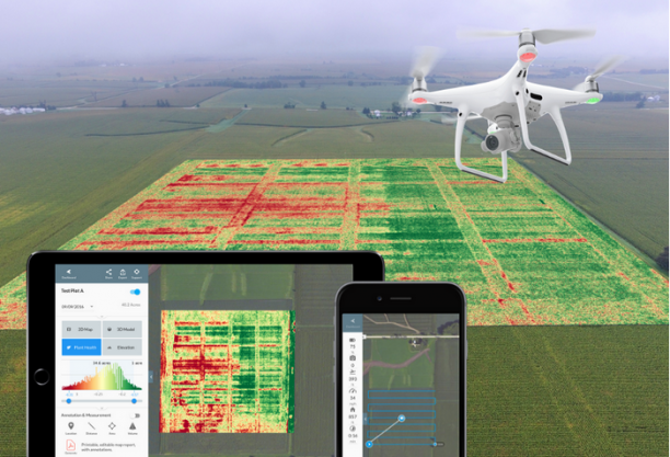
Mapping refers to the practice of interpreting topographical and orthomosaic images. Drone mapping is a powerful tool to generate 2D maps and 3D models to be used in areas of survey, construction, and engineering.
Assume, that you are planning to do a construction project on a 500-acre land. You will need a detailed analysis of soil, topography, and structures around. The type of soil, sandy, marshy or rocky would influence how you proceed. In the case of inclined land, exact dimensions have to be known to plan accordingly. Such things need to be researched before starting. This if not done properly, would lead to delays and escalating costs later on.
A few years ago to obtain a detailed aerial photogrammetric map, either a manned aircraft had to be flown over the desired place, or satellite imagery was used. The process was expensive and we had to compromise on the quality of data obtained. The introduction of drone mapping in the industry has reduced costs and time but increased the quality of data.
Why prefer drones over manual mapping methods?
Manual mapping of such a large area of land would take weeks or months to complete. Also, the data will be vulnerable to natural human errors. Drones are a much more efficient, quicker and practical way to do such a task. They can do a mapping mission in 20% of the time without disrupting the on-ground activities.
Heat mapping for anomaly detection
Thermal maps can give actionable insights about the structure of the soil. Topography and soil analysis combined can help make strategic decisions on layouts and duration of construction. They can also be used to detect structural issues. Thermal maps are a very powerful inspection tool as leaks and cracks can be easily detected in them.
3D modeling of land

Using Photogrammetry and LiDAR technologies a proper 3D model of the area can be obtained. Such models help construction managers to obtain a big picture and make decisions accordingly. Few best use cases of 3D mapping include:
- Forestry Management and Planning.
- Flood Modelling.
- Pollution Modelling.
- Mapping and Cartography.
- Urban Planning.
- Oil and Gas Exploration.
- Volumetric estimation
- Archaeology.
Asset management
Drones along with photogrammetric technology are being used to create up-to-date digital asset databases. These were earlier considered as operational challenges as manual methods are expensive and time-consuming.
This is especially helpful to the construction industry. Clients are regularly updated on the construction progress using its 3D maps. Also, managers can analyze the stockpiles of raw materials and make strategic decisions.
For the oil and gas industry, asset management is very important. Here sending humans for inspection is dangerous and expensive. Manned aircraft are inexpensive but don’t provide comprehensive data. The data is not structured and hence hardly actionable. Using drones there is a 50% reduction in costs and up to 33% efficiency gain.
How farmers can save money with drone mapping?

Agriculture is predicted to be the most benefited industry from drones. Farmers can analyze their crops and obtain crucial data to assist in decision making. Using Normalized Difference Vegetation Index (NDVI) imagery they can determine the health of plants. Timely detection of diseases and nutritional deficiencies can help farmers take necessary steps before major damage.
Thermal cameras can be used to detect irrigation leakage in farms. Using the topographic maps farmers can plan the planting pattern of their crops in a better way and also analyze areas of fertile and infertile soil.
Written and edited by: Palak Kumar

